


UN Backs Fairer World Maps in Landmark Vote to Restore Africa’s True Scale


(GAB) — The United Nations General Assembly has overwhelmingly endorsed an African-led campaign to transform how the world is represented on maps, adopting a resolution that encourages the use of equal-area projections that show Africa and other regions closer to their true geographic scale.
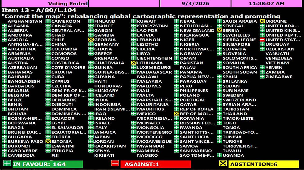
The resolution, titled “Correct the Map: Rebalancing Global Cartographic Representation and Promoting Equitable Representation of the World’s Regions, Particularly Africa,” passed with 164 countries voting in favor. The United States cast the only opposing vote, while Estonia, Georgia, Lithuania, Moldova, Serbia and Ukraine abstained.
Sponsored by Togo on behalf of the African Group and backed by the African Union, the resolution challenges the continued use of the Mercator projection in classrooms, media, public institutions and digital platforms.
The decision does not ban Mercator or legally require governments and organizations to adopt a particular alternative. Instead, it calls for wider use of equal-area projections, including Equal Earth, when the objective is to compare the relative size of continents accurately.
“A fair map does not change the geography of the world. It changes how we see the world,” Togo’s Foreign Minister Robert Dussey told the General Assembly before the vote.
Africa’s Size, Distorted for Generations
Created by Flemish cartographer Gerardus Mercator in 1569, the Mercator projection was designed primarily for maritime navigation. It preserves direction, making it useful to sailors, but dramatically enlarges territories near the poles while making equatorial regions appear smaller.
One of its most striking distortions is the comparison between Africa and Greenland. On many Mercator maps, the two appear roughly similar in size. In reality, Africa, covering more than 30 million square kilometers, is approximately 14 times larger than Greenland. Africa is also large enough to contain the United States, China, India, Japan, Mexico and much of Europe combined.
For African governments and campaigners, the issue extends beyond cartographic mathematics. They argue that generations of students have been taught to see a world in which Europe and North America appear physically dominant while Africa, South America and parts of Asia are visually diminished.
“Maps shape our understanding of the world,” Dussey said. “They guide education, nourish the imagination and influence collective perceptions.”
Introducing the resolution, Dussey said correcting those distortions was a matter of scientific accuracy, education and what he described as “cognitive justice.” He stressed that the initiative was not directed against any country and did not seek to erase Mercator’s historical value in navigation.
The resolution instead promotes the use of projections that preserve the proportional area of continental landmasses. The Equal Earth projection, developed by an international team of cartographers in 2018, is the model preferred by the African Union.
A Symbolic Victory With Practical Ambitions
Although General Assembly resolutions are generally non-binding, the vote gives substantial diplomatic weight to the campaign. Its long-term significance will depend on whether national governments, education authorities, publishers, news organizations and technology companies change the maps they use.
Africa No Filter, one of the organizations behind the campaign, said it wants accurate maps to become standard in “schools, textbooks, newsrooms, businesses” and major digital platforms. The resolution also encourages cooperation among UN agencies, regional bodies, academic institutions, researchers and technology companies. That cooperation could support new teaching materials, greater geographic literacy and stronger geospatial capacity in developing countries.
Togo is expected to continue pushing for implementation through the African Union and international partners, including discussions with educational institutions and digital mapping companies.
France has already announced that it will move away from Mercator in official world maps and use the Eckert IV projection, another equal-area model. French Foreign Minister Jean-Noël Barrot described correcting a distorted representation of the world as “an act of truth.”
United States Stands Alone
The United States rejected the resolution, arguing that the General Assembly should concentrate on more urgent international challenges. The American representative described the proposal as part of a broader ideological agenda and dismissed such resolutions as “barnacles on our work here,” according to the UN record of the debate.
Several countries that supported the resolution nevertheless emphasized that it must not affect international borders, territorial disputes or questions of sovereignty. Ukraine and Serbia abstained after raising concerns about political boundaries appearing on materials associated with the Equal Earth website. The European Union said the resolution applied strictly to continental proportions and did not endorse any website’s depiction of disputed territories.
India, which voted in favor, said the measure should be understood as supporting equal-area projections generally, rather than requiring every institution to use one specific design.
Those qualifications underscore a central scientific reality: no flat map can reproduce every feature of a spherical Earth perfectly. Every projection makes compromises among area, shape, distance and direction. The resolution therefore focuses on selecting maps suited to their intended purpose.
More Than a Cartographic Debate
The vote comes amid a broader African push for greater influence in global institutions and more control over how the continent is represented internationally.
African leaders have long argued that the continent remains underrepresented in institutions created under a post-Second World War order, including the UN Security Council and major international financial organizations. The map campaign adds a cultural and educational dimension to that debate.
For its supporters, correcting Africa’s scale will not by itself alter global power or economic inequality. But it challenges one of the most familiar images through which that power has been understood.
The General Assembly’s decision also demonstrates what African countries can achieve when negotiating as a united bloc. Of the 171 countries that participated in the vote, all but seven supported the resolution.
“Correcting the map means choosing fidelity to the facts,” Dussey told delegates.
The geography has never changed. What may now begin to change is how billions of people are taught to see it.
Global Africa Brief reviewed the UN General Assembly proceedings, the UN meeting report and the adopted resolution record.


Comments